Western states face above-normal wildfire threats this summer. New maps reveal which areas are most at risk.

All Western states are expected to face a higher-than-normal threat of wildfires this summer, according to the latest projectionsreleased Wednesday by the National Interagency Coordination Center.
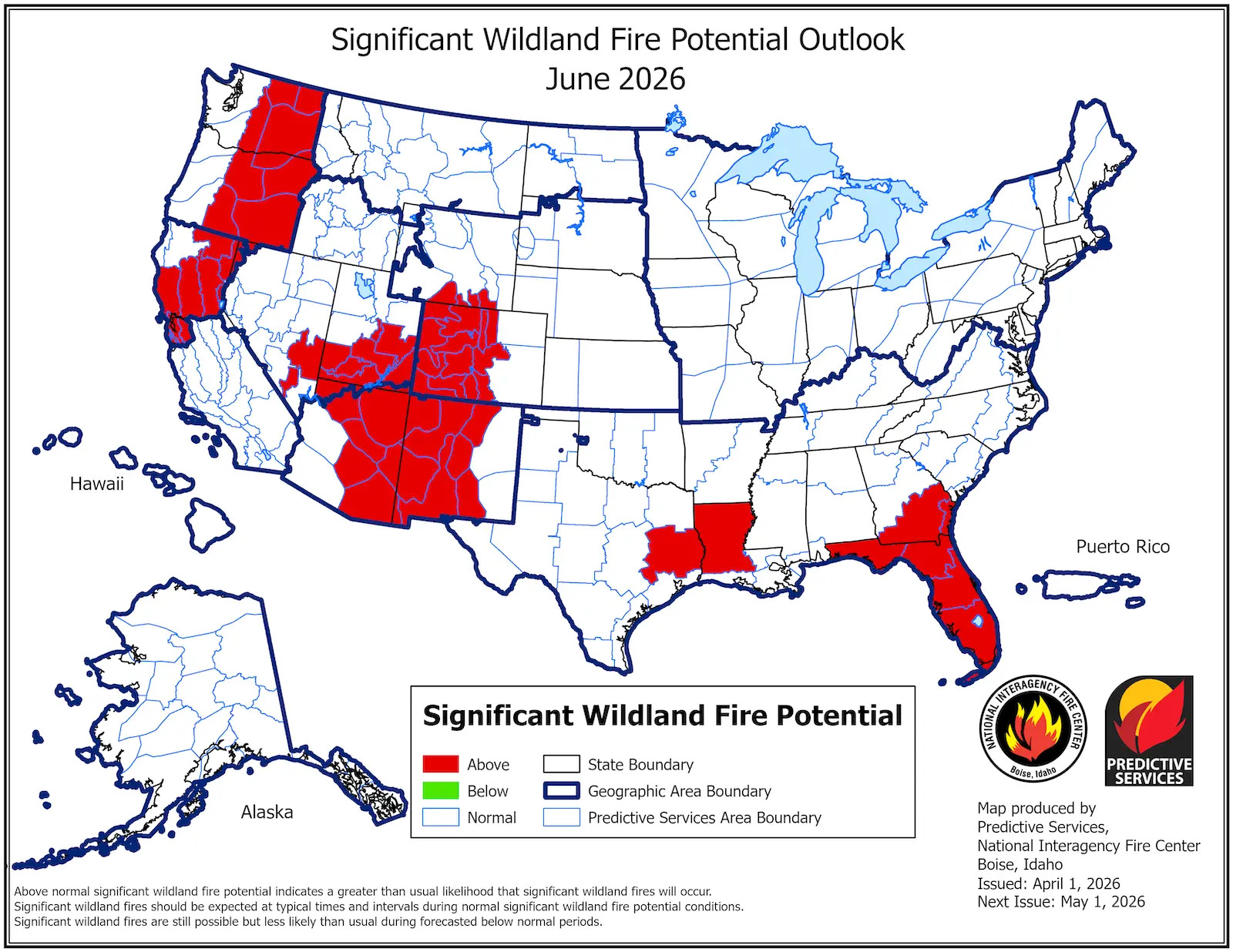
The government-run center releases monthly reports forecasting fire risks for the next four months, and the change since the March outlook is staggering. The agency shows high risk in red on its maps, and the June forecast as of March 2 showed a small band of red in the Southwest. But, citing a persistent snow drought, rapid snowmelt and recent unprecedented heatwavethe latest maps show red extending across the Southwest and into the Rocky Mountains, Pacific Northwest and northern California.
In June, snow typically lingers in many mountain ranges and melting snow wets the landscape, he said. Not this year.
The latest forecasts indicate that snowmelt in the Four Corners region has occurred “not only several weeks or months earlier than normal, but also four to six weeks earlier than the earliest melt dates previously recorded.” The recent heat wave also withered the West. Albuquerque, for example, recorded its first 90-degree temperature on March 21, more than six weeks earlier than its previous date, in 1947. Las Vegas’ daily average of 73.1 degrees in March would have broken the city’s April record.
Picture 1 of 2
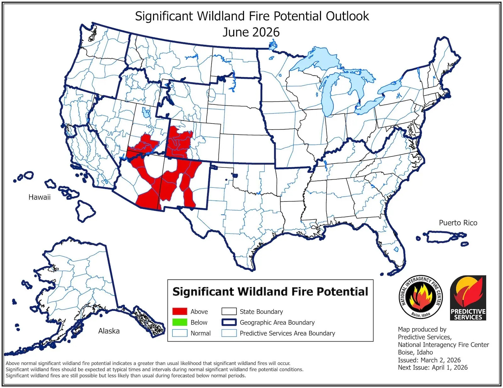
Overall, there was less snow cover and higher temperatures than virtually any winter on record. This is a situation which, according to climatologists, would be practically impossible without climate changeand the maps reflect this reality.
“That doesn’t mean all these areas are going to burn,” said Alastair Haydenprofessor at Cornell University and former division chief of the California Governor’s Office of Emergency Services. Last year, for example, the Pacific Northwest experienced higher than normal risk but was largely spared. Local phenomena, such as wind and precipitation, also play a major role. “But when I look at the forecast, fires generally tend to occur in one of those locations.”
The only notable place on the latest maps that seems safe at the moment is Southern California, although that’s because fire season it usually doesn’t start until later in the summer, or even into the fall. There are also surprising red spots, like in Florida, which is experiencing a drought. But the West is by far the biggest concern. “Keep an eye on July,” Hurteau said. “July 4 is the highest fire day of the year.”
The immensity of the land that could be threatened simultaneously worries Hurteau. “Our firefighting system depends in part on the entire region not being on fire at the same time,” he said. Fire crews rely on the ability to move from one hot spot to another. If there are too many at once, resources could run out.
The number of acres that burned across the country through March is already 231 percent of the 10-year average. A wet spring, however, could change everything. It has rained recently in Albuquerque, where Hurteau is based, and if that continues, the fire risk could decrease significantly. This is what happened last year.
“I’m sure that’s what all the firefighters are hoping for too, because that would be nice,” Hurteau said. “But hope is not a good strategy.”
This story was originally published by Grist. Subscribe to the weekly Grist newsletter here.


