Winds Whip Up Fires and Dust on the Southern Plains

High winds coupled with dry conditions fueled fast-spreading wildfires across the southern Plains of the United States during the winter of 2026. On February 17, several large fires broke out in the Oklahoma panhandle and quickly burned tens of thousands of acres of grassland and brush. The winds also caused dust storms and low visibility across the region.
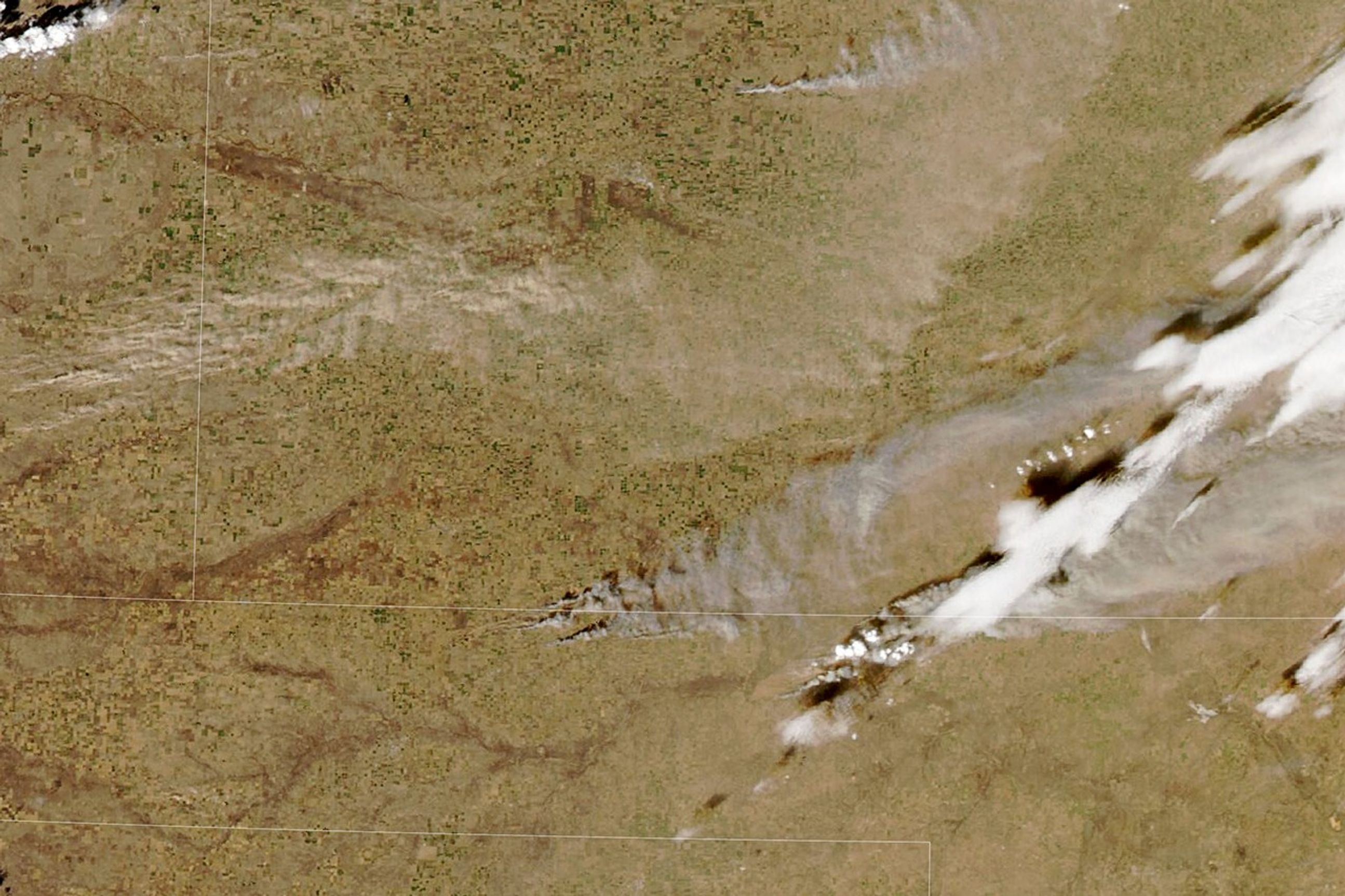
Smoke from several fires and wind-blown dust spread across the plains on the afternoon of February 17, when the Moderate Resolution Imaging Spectroradiometer (MODIS) on NASA’s Aqua satellite acquired this image. The Ranger Road Fire, the largest of the group, broke out shortly after noon that day near Beaver, Oklahoma, and spread rapidly throughout the afternoon. By evening, it had burned as far as Kansas and consumed about 145,000 acres (587,000 hectares), the Oklahoma Forest Service reported. Combined with other nearby fires, including the Stevens and Side Road fires near Tyrone, Oklahoma, more than 155,000 acres burned that day, the agency said.
The Ranger Road Fire had the characteristics of a “fast fire”, a particularly dangerous and destructive type of fire characterized by rapid spread. These fires typically burn in grasslands and shrublands rather than forests, often occur in fall and winter when fuels are dry, and are propelled by strong winds. Wind gusts of up to 70 miles per hour were measured in the Oklahoma and Texas panhandles on Feb. 17, the National Weather Service said.
The fires destroyed several structures, threatened farmland and livestock and prompted evacuation orders for parts of western Oklahoma and southern Kansas, according to media reports. Oklahoma’s governor has declared a state of emergency for Panhandle counties.
Persistent winds and dry conditions led to further fire growth on February 18. The Ranger Road and Stevens fires nearly doubled in size that day, the Oklahoma Forest Service reported. On February 19, a Red Flag Warning remained in effect for the Texas and Oklahoma panhandles, with forecasts calling for wind gusts of up to 40 miles per hour and very low relative humidity.
Windblown dust has created other serious hazards in the area. Near Pueblo, Colorado (west of this scene), poor visibility led to a fatal pileup of dozens of vehicles on Interstate 25, according to reports. And in southern New Mexico, authorities warned travelers of dangerous conditions due to dusty winds.
NASA Earth Observatory image by Lauren Dauphin, using NASA MODIS data ÉOSDIS LANCE And GIBS/Worldview. Story by Lindsey Doermann.
- AccuWeather (February 18, 2026) Wildfires in Oklahoma and Kansas are ravaging an area larger than New York City as new fires break out in Texas. Accessed February 19, 2026.
- AP News (February 18, 2026) 5 dead in Colorado highway crashes after flying dirt makes visibility difficult. Accessed February 19, 2026.
- NASA Earth Observatory (December 12, 2024) The threat of rapid fire. Accessed February 19, 2026.
- Oklahoma Department of Agriculture, Food and Forestry (2026) Forest Services. Accessed February 19, 2026.
- Oklahoma Forest Service, via Facebook (2026) posts. Accessed February 19, 2026.
- The Oklahoman (2026) Oklahoma wildfires, smoke map: Track the latest wildfires, red flag warnings. Accessed February 19, 2026.


