Tracy Arm’s Post-Tsunami Landscape – NASA Science

Sculpted over millennia by the pressure and movement of glacial ice, the valley walls that cradle Tracy Arm Fjord in southeast Alaska continue to be reshaped. In the summer of 2025, following the rapid retreat of the South Sawyer Glacier, a large landslide threw rocks into the fjord, changing the entire landscape in minutes.
The slide peaked on the morning of August 10, 2025, when at least 64 million cubic meters of rock slid down the slope. Material entering the fjord caused a tsunami that destroyed trees and other vegetation on the opposite wall of the fjord up to 1,578 feet (481 meters) above sea level. Although this peak was the highest point reached by the tsunami, the coasts and islands downstream of the fjord also suffered significant destruction.
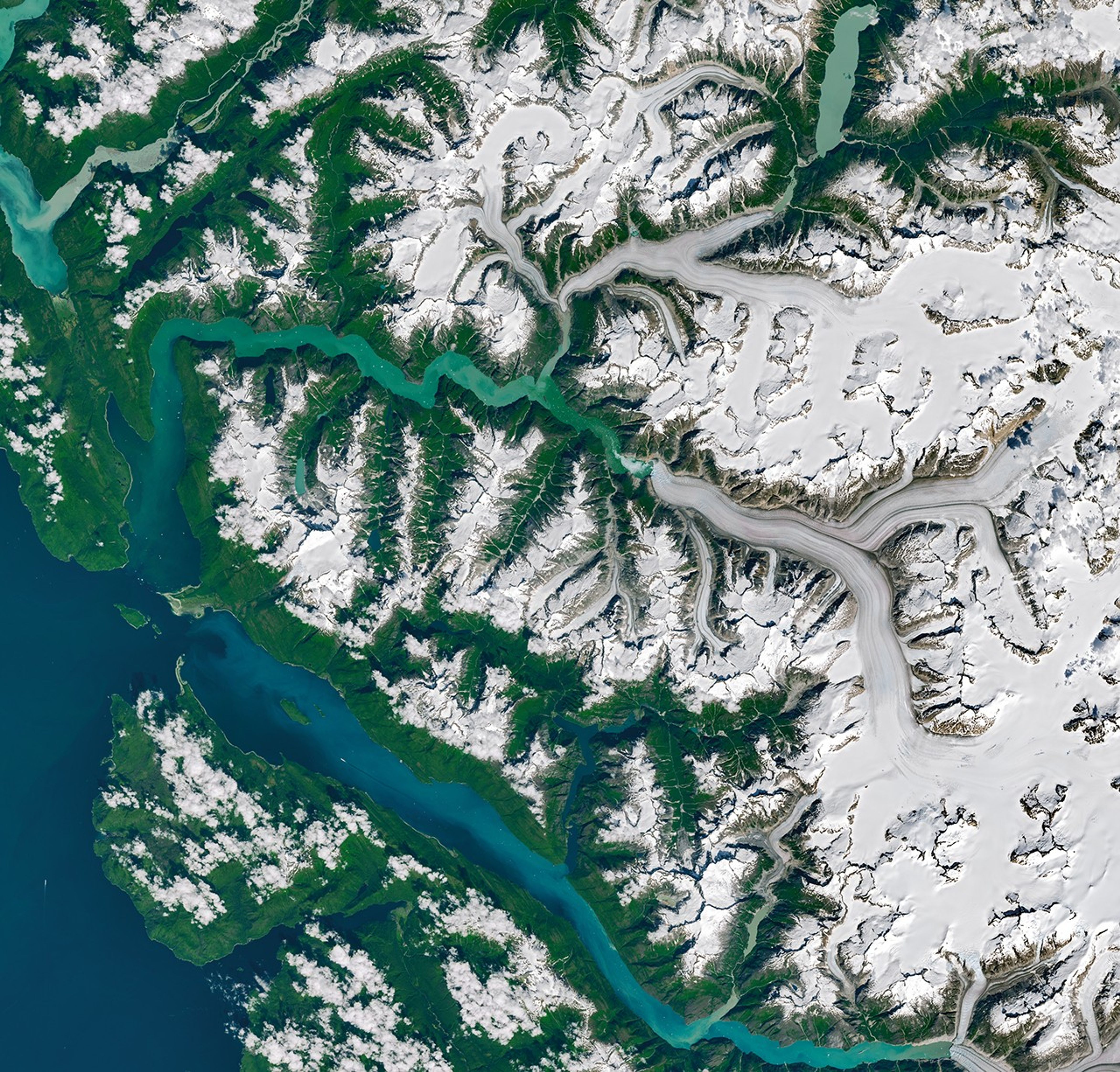
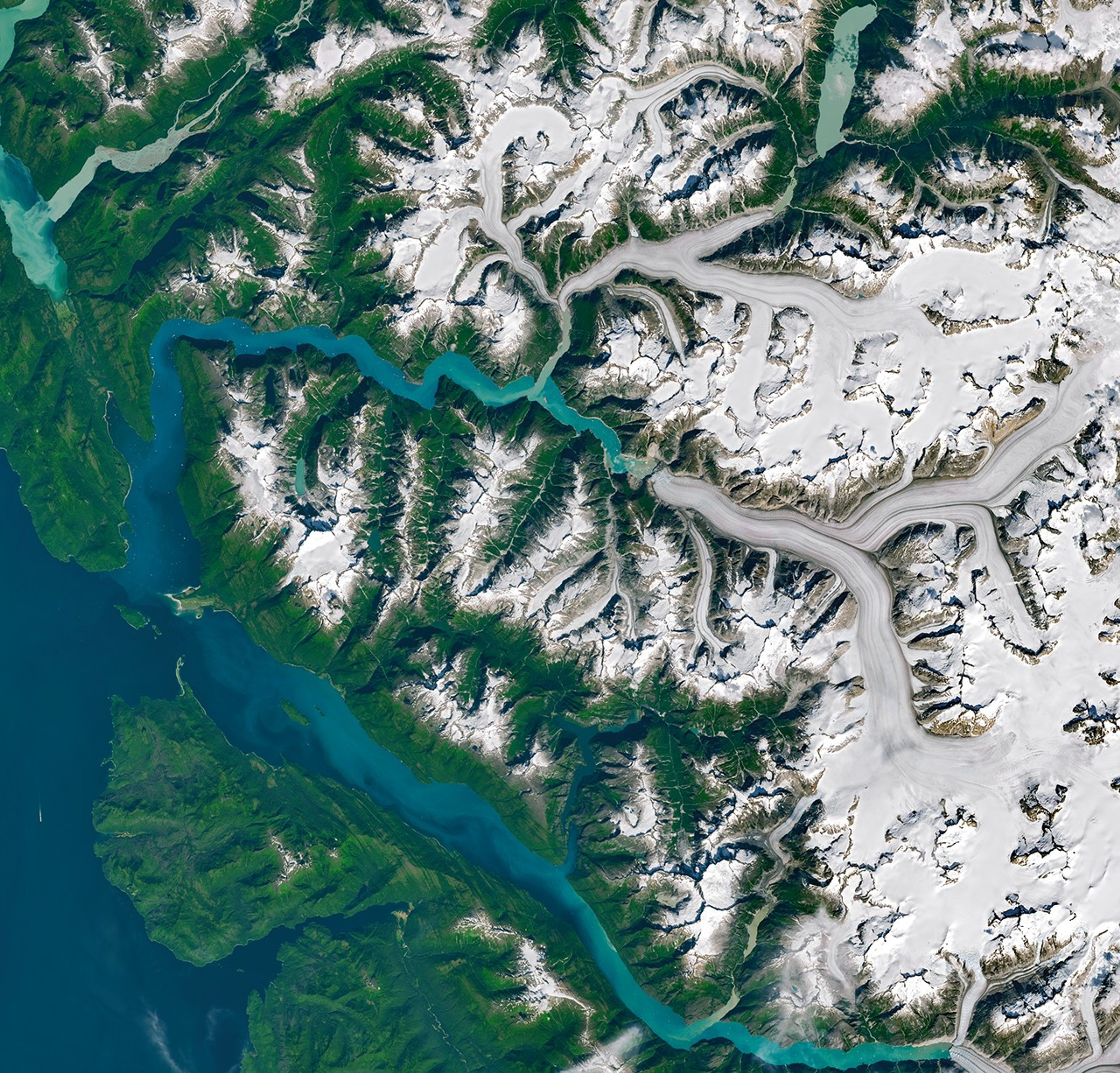
NASA-USGS Landsat satellites captured these images on July 26 (left) and August 19 (right), before and after the event, respectively. “The bright scar from the landslide on the north side of the fjord is striking, as is the ‘bathtub’ ring around the fjord showing areas where forest was flattened by the tsunami,” said Dan Shugar, a geomorphologist at the University of Calgary.
Note that Sawyer Island, about 9 kilometers from the landslide, also changed from green to brown. Only a few trees still stood at the highest elevations of the island.
In the months since the slide, Shugar and his colleagues combined satellite, airborne, and ground observations with eyewitness reports and simulations to build a more complete picture of how the event unfolded. Their analysis, detailing the event from its beginnings to its consequences, was published on May 6, 2026 in the journal Science.
In addition to the details described above, the researchers showed that water continued to flow around the fjord – a phenomenon known as “seiche” – for more than a day. Both the landslide and the seiche produced seismic signals detected around the world, the former equivalent to a magnitude 5.4 earthquake.
Landsat images also reveal significant retreat at the front of the South Sawyer Glacier in less than a month. “Some of this happened between the date of the first image and the date of the landslide,” Shugar said. “But part of that comes from the landslide itself, which broke off much of the terminus of the South Sawyer Glacier, leading to a flow of icebergs into the fjord.”
The exact mechanisms causing the landslide remain unclear and could involve a combination of factors. Precipitation, moderate before the event, and the rapid retreat of glaciers can both destabilize a slope. What is clear, however, is that the retreat of the glacier exposed a new area of open water, making it vulnerable to a tsunami that could reorganize the landscape.
No one was injured during the event, although some were surprised. Kayakers camping on Harbor Island near the mouth of the fjord saw their equipment swept away, and passengers aboard a small cruise ship in nearby Endicott Inlet reported fluctuating water levels and a strong current associated with the tsunami. Brentwood Higman of Ground Truth Alaska, co-author of the paper, noted that a glacier’s shift from relative stability to renewed retreat, visible in satellite images, could serve as an important indicator that an area has become more susceptible to landslide and tsunami hazards.
NASA Earth Observatory images by Michala Garrison, using Landsat data from the US Geological Survey. Photograph by John Lyons/US Geological Survey. Story by Kathryn Hansen.
- Alaska Public Media (August 12, 2025) ‘Pure chaos out of nowhere’: Mega-landslide and tsunami devastate Tracy Arm south of Juneau. Accessed May 7, 2026.
- AP News (April 12, 2026) Alaska cruise lines avoid popular excursion to Tracy Arm after massive landslide. Accessed May 7, 2026.
- NASA Earth Observatory (November 12, 2024) Greenland Tsunami Assessment. Accessed May 7, 2026.
- Shugar, DH, and others. (2026) A 481 meter high tsunami landslide in an Alaskan fjord frequented by cruise ships. Science392 (6798).
- University of Alaska Fairbanks (August 12, 2025) The landslide caused by the tsunami was the largest in a decade, according to the seismic center. Accessed May 7, 2026.
- US Geological Survey (August 13, 2025) 2025 Tracy Arm landslide before and after satellite imagery. Accessed May 7, 2026.


